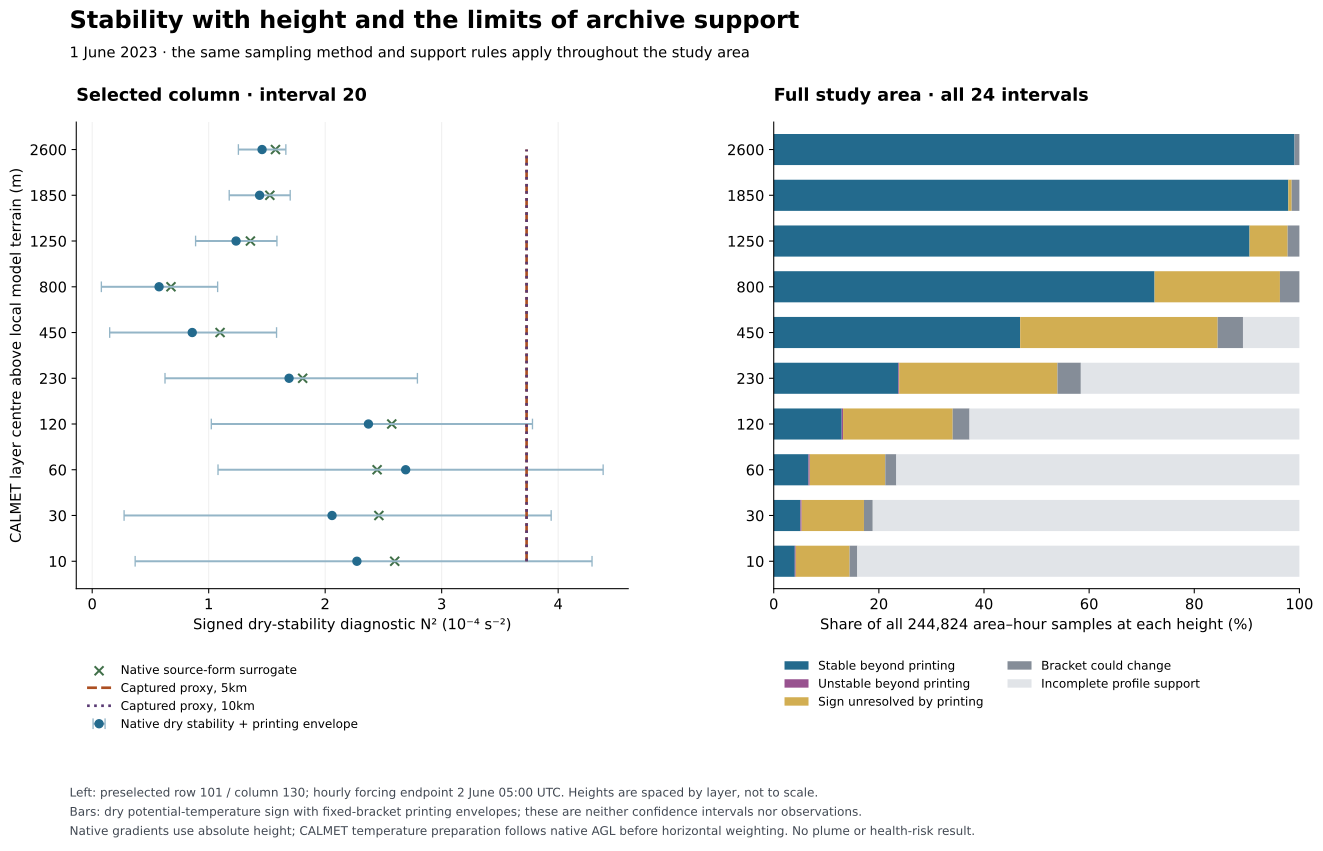
The terrain-blocking calculation uses a low-level stability proxy at every model height. A comparison with the archived vertical profiles shows where that proxy differs from the atmosphere represented by the regional model. This identifies a limitation to evaluate before adopting the adjusted winds for plume transport. It does not identify a corrected wind field.
The study covers all 10,201 cells in the original area, all 24 intervals of 1 June 2023 and all ten model layer centres. All 13 existing community, station and site references use the same method. The previously selected column and its four neighbours are retained as an explanatory example; they do not determine the study-wide criteria. These labels are not a complete population or exposure-receptor inventory.
Atmospheric stability describes how the atmosphere resists or promotes vertical displacement. A temperature inversion is one possible stable structure; a positive dry-stability diagnostic alone does not establish an inversion. Flare heat, plume rise and subsequent vertical mixing depend on conditions with height, so a surface value cannot by itself establish transport through the valley.
CALMET’s terrain-blocking routine uses a Froude-number test to decide whether to redirect uphill flow along the terrain. Its documented rule preserves wind speed while changing direction. The preceding stage trace found that differing redirects in neighbouring cells produce most of a large model-implied vertical-motion increment, which smoothing partly offsets. CALMET user guide, §2.2.1.
The captured source proxy is evaluated as N² = 9.8 × (GAMMA + 0.01) / TEMP2D, in s⁻². It has one value per horizontal cell and interval, repeated through the column. In this configuration, GAMMA normally comes from model temperatures between the lowest centre, 10 m, and 200 m. A convective-history condition can instead assign −0.0098 K/m. Adding 0.01 leaves a small positive value in that branch; it is not exactly neutral.
The regional comparison uses archived pressure, temperature and height at adjacent native mass levels enclosing the same absolute height as each CALMET layer centre. Dry potential temperature is reconstructed as θ = T × (1000/P)^(287.04/1004), with pressure in hPa. Native interval stability is N² = 2g(θupper − θlower)/[(θupper + θlower) × Δz], using g = 9.8 m/s². Signed negative values are retained. A second calculation uses the source’s temperature-gradient-plus-0.01 form on those same native intervals, to distinguish part of the thermodynamic-formula effect.
Each cell retains its actual four native neighbours and interpolation weights. The four interval diagnostics are combined using those weights; this is not the stability of a newly reconstructed horizontal temperature profile. Every neighbour must bracket the target. No missing neighbour is replaced, weights are not renormalized and no below-first-level or above-top extrapolation is introduced.
The two temperature operators differ. CALMET prepares its temperatures at the requested height above each native column’s own ground before horizontal weighting. This diagnostic samples a common absolute height. Its differences therefore combine vertical structure, terrain representation and sampling choices; they are not an exact reconstruction error in GAMMA. The captured pre-adjustment temperature comes from the current endpoint-derived lowest model temperature. The convective mixing-height condition carries prior model history. Native WRF is the shared upstream model, not an independent observation. The height datum and geopotential/geometric approximations also remain.
The retained archive prints temperature to 0.1 K, pressure to 1 hPa and mass-level height to 1 m. Thin-layer gradients can be sensitive to that rounding. For each fixed native bracket, the analysis evaluates all extrema of temperature ±0.05 K, pressure ±0.5 hPa and height ±0.5 m. It retains the resulting envelope. Targets within 0.5 m of a native level are marked bracket-ambiguous and excluded from robust-sign counts.
These envelopes describe printing alone. They are not confidence intervals and do not include forecast error, unresolved terrain or inversions, humidity, time sampling or measurement uncertainty. A dry-stability sign is called resolved only when the entire envelope has that sign and the bracket is unambiguous.
Of 2,448,240 area–height–hour samples per configuration, 1,574,236 (64.3%) have all four native profiles in range. Of those supported samples, 63,752 are bracket-ambiguous. Among the 1,510,484 remaining samples, 1,124,025 are positive beyond printing, 2,691 negative beyond printing and 383,768 have unresolved sign. These sample counts are not population fractions or frequencies of real weather.
| Model centre above local terrain | Complete profile support | Of all area–hour samples |
|---|---|---|
| 10 m | 38,935 / 244,824 | 15.9% |
| 30 m | 46,127 / 244,824 | 18.8% |
| 60 m | 57,105 / 244,824 | 23.3% |
| 120 m | 91,198 / 244,824 | 37.3% |
| 230 m | 143,033 / 244,824 | 58.4% |
| 450 m | 218,542 / 244,824 | 89.3% |
| 800 m | 244,824 / 244,824 | 100.0% |
| 1,250 m | 244,824 / 244,824 | 100.0% |
| 1,850 m | 244,824 / 244,824 | 100.0% |
| 2,600 m | 244,824 / 244,824 | 100.0% |
Support is especially limited near the ground because the native and fine terrain differ and the first atmospheric mass level lies above native ground. Exclusion is a data-support finding; it does not mean there is no wind or no exposure at that location.
Vector figure. The left panel uses the preselected column, interval starting 20:00 fixed PST, driven by the 2 June 05:00 UTC endpoint. Layer heights are equally spaced for readability. The right panel uses every original study cell and interval, with mutually exclusive support/sign categories. Both terrain configurations share the native comparison and its support mask.
The source proxy is approximately 3.729 × 10⁻⁴ s⁻² throughout this column at the selected time. Native local stability varies with height. For example, at the 1,250 m model centre it is about 1.235 × 10⁻⁴ s⁻², with a printing envelope of 0.888–1.586 × 10⁻⁴ s⁻². The source-form native surrogate is 1.358 × 10⁻⁴ s⁻². These differences exceed printing alone at that sample, while the sampling and model limitations above still apply.
The native profile is positive beyond printing at all ten displayed heights. Consequently, this example does not support an explanation that the terrain adjustment merely misclassified a locally unstable layer as stable. It shows that a single proxy does not reproduce the vertical strength of the archived stability. Nor is a local interval value automatically the effective stability of the whole obstacle column used in terrain blocking. No alternative Froude decision or replacement wind was calculated.
Across the full supported area, the 5 km case has 2,645 samples with a positive source proxy and robust negative native dry stability; 301 also have a captured horizontal-vector change. The corresponding 10 km counts are 2,645 and 610. These disagreements are retained, but no percentage is presented as a physical error rate: the operators and the atmospheric information they represent differ.
The EPA’s December 2016 IWAQM reassessment discusses concerns about CALMET’s stability and terrain-deflection treatment. That report addresses US long-range applications and includes descriptions originating in a 2009 draft; it is not a B.C. permit decision or a validation of this study. Its domain-mean lapse-rate description does not match our spatially local IUPT=-1 path. The local source review confirms the relevant remaining issue: the stability proxy varies horizontally but is reused through height. EPA-454/R-16-007, §§2.2–2.7.
The next work should establish which atmospheric representation is suitable for local transport, rather than select controls because they reduce the largest vertical value. Priorities are:
T, P, PB, PH, PHB and QVAPOR fields together with HGT, coordinates, Times, vertical-coordinate arrays, production and assimilation metadata. These variables must be interpreted using the documented WRF conversion rather than treating perturbation temperature as air temperature. Preserve the native archive’s missing and truncated levels; greater numeric precision does not provide finer physical resolution.Current linked flare geometry, heat and emissions remain separate prerequisites for concentration prediction. The public plume continues to use its labelled illustrative solver. This study changes the research priorities, not residents’ estimated exposure.
The experiment was declared before these temperature/stability results were calculated. It extracts 1,920,000 temperature and pressure values each from 48,000 native column profiles; heights and time labels match the earlier native inventory exactly. All printed-variable envelopes contain their nominal values. Independent parsing and calculation reproduce all 34 compared arrays, 106 summaries and 8,640 reference/stencil rows exactly. A separate scalar search and full endpoint-corner calculation covers 8,058 native intervals. An initial independent-checker ambiguity flag differed only on unsupported samples; its correction and original record are retained in the linked checks. Captured source temperatures are identical between the two terrain cases, while lapse-rate fields differ at some locations; those differences are preserved.
Summary and support counts, all reference profiles, selected column and four neighbours, per-height results, per-interval results, root checks, independent comparison, protocol, and source and interpretation review.
The retained local reproduction archive also includes the complete native profiles, full comparison arrays, all four bracket indices and heights, source fields and code. The public tables supply the report’s numerical values without exposing local machine paths. No wind or transport model was rerun for this comparison.