Follow-up: the airport observation comparison finds substantial speed overprediction, and the expanded vertical audit finds that the large interior terrain-following W excursion persists. The hour_fixed_PST labels in this report’s point CSV are interval starts; native wind forcing targets the interval end. Existing case-to-case statistics are unchanged. The new paired data provide explicit interval bounds and observation times.
11 September 2026 · Domain-sensitivity experiment · Historical weather: 1 June 2023
Adding surrounding terrain changes the calculated winds unevenly across the study area. Three new full-day runs extend the computational grid from 20.2 km to 40.2 km square, retaining the same 200 m spacing, weather day and physical settings. The comparison covers every original grid cell, all 24 intervals and all ten wind levels. The assessment is intended to cover all communities within its eventual domain.
Ten kilometres of terrain were added on every side. All 10,201 original cell centres now have a complete nominal 10 km terrain search available. In the smaller grid, only one cell had that support. This resolves the specific truncated-search problem identified in the earlier wind-driver study. Further domain extensions and resolution tests are needed to establish convergence.
The original inner terrain and all six surface-property inputs reproduce exactly, including their written model-input values. Twenty native WRF tiles supply the expanded weather footprint; every selected record from the original six tiles matches its retained source. The three expanded runs completed normally, and all 87,266,160 wind-component values passed structure, time and finite-value checks.
The table reports the change caused by enlarging the domain. A vector difference includes both wind speed and direction. These are nominal 10 m winds above model terrain, not pollutant concentrations or breathing-height measurements.
| Unchanged physical setting | Mean difference across all inner cells and intervals | Largest cell/interval difference |
|---|---|---|
| Blocking and slope adjustments off | 0.0018 m/s | 0.257 m/s |
| Both adjustments; 5 km terrain radius | 0.0509 m/s | 3.859 m/s |
| Both adjustments; 10 km terrain radius | 0.0620 m/s | 4.791 m/s |
The small mean change does not rule out larger changes at particular locations and hours. The both-off control also changes slightly across the grid, so the enlargement cannot be described as isolating only missing ridges. It changes the supplied weather footprint and boundary processing as well. All thirteen retained site, station and place references have a both-off change below 0.001 m/s.
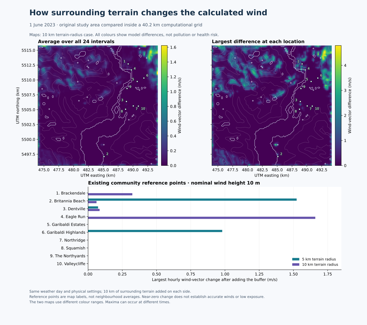
Within the expanded domain, changing the terrain radius from 5 to 10 km still gives a mean near-surface vector difference of 0.157 m/s and a maximum of 4.769 m/s across the original area. Neither setting is selected as more accurate from this comparison.
Each entry uses the same complete day. Values are mean / maximum vector difference in m/s between the smaller and expanded domain at that point. Maxima need not occur at the same hour. These place labels are not neighbourhood boundaries or population averages.
| Place label | 5 km terrain radius | 10 km terrain radius |
|---|---|---|
| Brackendale | <0.001 / <0.001 | 0.026 / 0.323 |
| Britannia Beach | 0.063 / 1.524 | 0.003 / 0.062 |
| Dentville | 0.003 / 0.073 | 0.004 / 0.084 |
| Eagle Run | <0.001 / <0.001 | 0.074 / 1.660 |
| Garibaldi Estates | <0.001 / <0.001 | <0.001 / <0.001 |
| Garibaldi Highlands | 0.163 / 0.980 | <0.001 / <0.001 |
| Northridge | <0.001 / <0.001 | <0.001 / <0.001 |
| Squamish | <0.001 / <0.001 | <0.001 / <0.001 |
| The Northyards | <0.001 / <0.001 | <0.001 / <0.001 |
| Valleycliffe | <0.001 / <0.001 | <0.001 / <0.001 |
A small change here means that this particular domain test makes little difference at that reference point. It does not establish accurate local weather or low exposure. All site/station references and hourly values are included in the downloadable table.
The whole-grid calculation covers unnamed locations as well as these ten labels. A new community-coverage audit also checks public reserve boundaries and municipal land-use polygons. Three mapped reserve polygons overlap the study area but contain no regular 200 m grid centre. They demonstrate why a future exposure assessment needs additional receptors within relevant occupied areas, alongside its regular grid.
This experiment supplies a better-supported terrain calculation and a reproducible measure of domain sensitivity. The next stages are to test additional domain/resolution choices against observed winds and vertical profiles, recover usable marine temperatures, and connect an applicable plume model to a current flare release case. Inflow, outflow, inversion and transition episodes need separate evaluation across the area. This one June day is not a climatology or an observed inversion case.
For health-oriented results, each pollutant needs an explicit receptor height, event timeline and matching averaging period. Compare project increments plus justified background and concurrent sources with the applicable B.C. objective or other clearly identified health benchmark. Individual VOCs require speciation; total VOC alone cannot establish benzene exposure. Objective comparisons do not predict an individual health outcome. Assessment criteria and sources, research and data priorities
The existing interactive plume remains a research illustration. The larger domain does not resolve the shared missing-sea-temperature assumption or demonstrate accurate plume rise, mixing or chemistry. The large terrain-following vertical components remain a physical-evaluation question; adding a buffer did not eliminate them.
The cases use CALMET 6.5.0, 1 June 2023 00:00–24:00 fixed PST (UTC−8), ten layers with faces at 0, 20, 40, 80, 160, 300, 600, 1,000, 1,500, 2,200 and 3,000 m above terrain, and the previously declared seasonal surface properties. The expanded grid is 201 × 201 in WGS84 / UTM zone 10N. Its minimum original-cell-centre boundary clearance is 10.1 km. A 10 km terrain-search buffer is a geometric provision, not proof of adequate meteorological or pollutant-transport boundaries. The model warning that resets SIGMAP to its native-weather-grid basis remains recorded.
An initial readback check exposed one terrain value at a binary rounding boundary. Applying the declared nine-decimal text formatting before binary conversion gives an exact match. No terrain, model setting or scientific tolerance was changed to pass the check.
Inputs, protocol, results and checks · Calculation scripts and control files · Hourly reference winds · Vector figure
Method and input sources: B.C. dispersion modelling guideline, B.C. WRF archive, Canadian terrain and surface-input documentation. Place labels originate from the retained OpenStreetMap extract; © OpenStreetMap contributors, ODbL.